History of the fields use
Photographs like the one below one taken during the Second World War as well as anecdotal evidence from long term residence confirms that the fields were intensively farmed at least during and from the 1940’s.
Maps dating back to the 1770’s record the fields being used for agriculture.
An aerial photo showing the fields in the centre of the image taken 16th October 1986 at 9:50 am for West Sussex County Council (copy supplied by Margaret Thornburn and Crispin Holloway). The field has clearly been ploughed and sown, possibly with winter wheat.
The Laines or Open Fields of Kingston 1773 map taken from Cooper (2000) with copy supplied by Margaret Thornburn and Crispin Holloway. The Kingston Hill Fields being the unnamed area on the top left of the drawing.
The Laines or Open Fields of Kingston 1773 enlarged map taken from Cooper (2000) with copy supplied by Margaret Thornburn and Crispin Holloway. The fields being outlined in red.
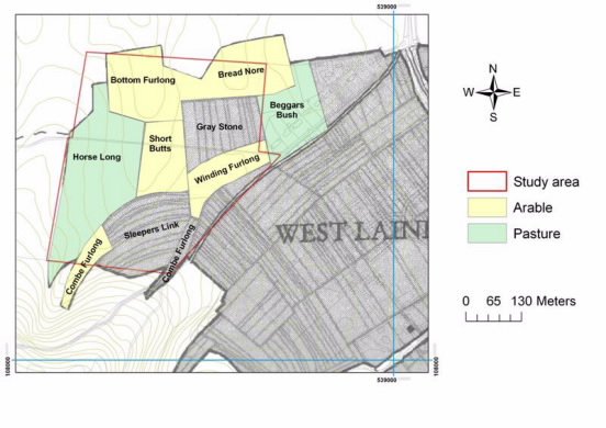
Furlong names and land use c 1775 supplied by Margaret Thornburn and Crispin Holloway. Data from map drawn by J. Merchant and held at the West Sussex Records Office (ref: Wiston number 5595).


